Your NorCal Property Wildfire Risk Evaluation Guide
Get a clear, practical property wildfire risk evaluation Northern California homeowners can use to protect their homes and stay insurable. Start your plan now.
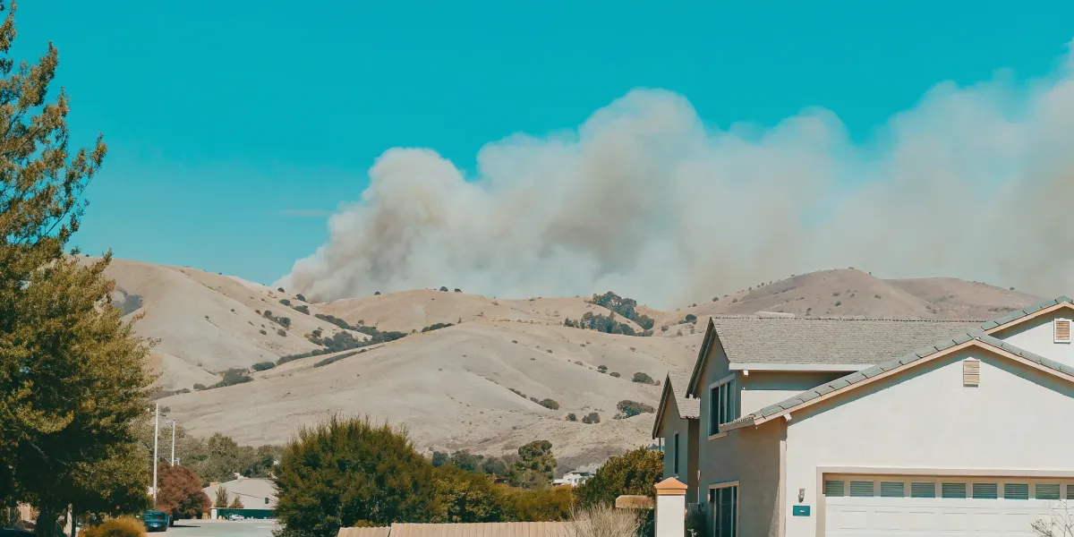
Receiving a non-renewal notice from your insurance company can feel like a punch to the gut. For many homeowners, it’s the first sign that the ground has shifted beneath them, leaving them feeling exposed and confused. The rules for staying insured are changing fast, and simply living in a certain zip code is no longer the only factor. Insurers are now using highly detailed models to zoom in on your specific property. The good news is that you can take back control. A thorough property wildfire risk evaluation Northern California homeowners can perform is the first step to understanding what insurers see, allowing you to take targeted actions to protect your home and your policy.
Key Takeaways
- Look Beyond Official Maps to Understand Your True Risk: Your property's official Fire Hazard Severity Zone (FHSZ) is just a starting point. Insurers now use detailed models that generate a specific risk score for your home, meaning the proactive steps you take to mitigate fire danger can directly improve your insurability, even in a high-hazard area.
- Focus on Embers and Defensible Space for Maximum Impact: Most homes are lost to wind-blown embers, not the main fire front. Prioritize the most effective actions: hardening your home by screening vents and installing a Class A roof, and maintaining a 100-foot defensible space to create a crucial buffer.
- Turn Knowledge into Action with a Specific Plan: Vague anxiety doesn't protect your home, but a clear plan does. Use professional assessments and online tools to pinpoint your property's unique weaknesses, then address them systematically to make your home more resilient and demonstrate your proactive efforts to insurers.
What Puts Your Northern California Home at Risk for Wildfire?
Understanding your home's wildfire risk goes beyond just knowing you live in a fire-prone state. It’s about looking at the specific environmental factors that can turn a spark into a disaster. Insurers and fire agencies evaluate your property based on a combination of elements, from the trees in your backyard to the slope of your land. By learning to see your property through their eyes, you can identify your biggest vulnerabilities and take targeted action to protect your home and family. These four key factors—fuel, topography, weather, and fire history—are the building blocks of your property’s unique risk profile.
Your Property's Fuel Load: Local Forests and Vegetation
The term "fuel load" simply refers to the amount of flammable material surrounding your home. This includes everything from dense forests and overgrown shrubs to dry grass and dead leaves. In Northern California, where vast forests are a defining feature of the landscape, this is a critical risk factor. Recent studies show that fires have driven the vast majority of tree cover loss in the state, and a warming climate is only making things worse. The more dense vegetation you have nearby, the more fuel a fire has to consume, allowing it to grow larger, hotter, and move faster. Managing this fuel is the foundation of creating a defensible home.
How Hills and Slopes Can Accelerate Fire Spread
If your home is built on or near a hill, your risk increases significantly. Fire moves much faster uphill than it does on flat ground. As a fire burns up a slope, the flames and heat pre-heat the vegetation above, drying it out and making it ignite more easily. This creates a chimney effect that can cause a fire to race up a hillside with terrifying speed. This is especially dangerous in areas with dense, homogenous forests and woodlands, which are already vulnerable to fire. Understanding your property’s topography is essential for planning effective defensible space and home hardening measures.
The Impact of Drought and Rising Temperatures
The broader climate plays a huge role in your home’s day-to-day fire risk. California is experiencing more frequent and severe heat waves, longer droughts, and a thirstier atmosphere. These conditions act as a threat multiplier, turning lush vegetation into dry, ready-to-burn fuel. According to NOAA, climate change has been a key driver in increasing the risk and extent of wildfires. This isn't a distant problem—it's the reason our fire seasons are getting longer and more destructive. These extreme weather patterns mean that even areas once considered low-risk are now facing new threats, making proactive preparation more important than ever.
Understanding Your Area's Wildfire History
Past fire activity is often a strong predictor of future risk. Researching your local area’s wildfire history can give you a clear picture of how fire behaves in your specific environment. It’s important to know that the recent increase in burned areas across California isn't a coincidence; it’s directly linked to human-caused climate change. You can use online resources from CAL FIRE or local fire safe councils to look up past fire perimeters near your home. This historical context helps you understand the specific threats you face, whether it’s fast-moving grass fires or intense forest fires, so you can tailor your preparedness plan accordingly.
How to Evaluate Your Property's Specific Wildfire Risk
Understanding your home's specific wildfire risk is the first and most critical step toward protecting your family and your investment. It’s about moving past the general anxiety of living in a fire-prone state and getting a clear, factual picture of your unique situation. This isn't just about looking at a map and seeing a color-coded zone; it's about understanding the factors that contribute to that risk level. Why is your property rated the way it is? What are the specific vulnerabilities of your home’s construction or the landscape around it?
Answering these questions gives you power. When you know exactly what you’re up against, you can create a targeted, effective plan. This knowledge is also what insurance companies are looking for. They are using increasingly sophisticated models to assess risk, and the more you can show that you understand and have addressed your property’s vulnerabilities, the better your chances are of maintaining affordable coverage. Think of this evaluation as building the foundation for your entire wildfire preparedness strategy. It transforms a vague threat into a manageable set of tasks you can tackle one by one.
Check CAL FIRE's Official Fire Hazard Maps
Your first stop should be the official maps from the state. California law requires the State Fire Marshal to identify and map areas based on the likelihood they will burn over a 30- to 50-year period. These Fire Hazard Severity Zones (FHSZ) maps are a reliable, high-level starting point for understanding your area's baseline risk. They classify land as Moderate, High, or Very High Hazard. Finding your property on these maps gives you an official designation that influences local building codes and defensible space requirements. It’s the essential first piece of the puzzle, providing the broad context for your home’s location within California’s fire landscape.
Use Online Tools to Assess Your Risk
While CAL FIRE's maps are fundamental, they don't tell the whole story. Insurers and fire professionals often use more detailed data to get a clearer picture of risk. You can access similar insights using specialized online tools. For example, companies like Pyrologix provide detailed wildfire risk assessments that analyze risk down to the community or even property level. These tools often factor in vegetation, weather patterns, and potential fire behavior in ways that broader state maps don't. Using them can give you a more nuanced view that often aligns more closely with how an insurance underwriter might see your property, helping you understand why your rates might be changing.
Get a Professional Property Evaluation
For the most accurate and personalized understanding of your risk, nothing beats having an expert walk your property. A professional wildfire risk assessment goes beyond what any map or online tool can show you. An assessor can spot vulnerabilities specific to your home’s construction, the age and type of your roofing, the exact placement of vents, and the condition of the vegetation in your defensible space zones. They can provide a detailed, prioritized list of actions to take. This kind of evaluation is invaluable for creating an effective mitigation plan and provides the credible, third-party documentation that can make a real difference when speaking with your insurance provider.
Pinpoint Your Home's Key Vulnerabilities
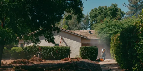
Once you have the data from maps and professional assessments, it’s time to focus on your home itself. Wildfires often destroy homes not through a giant wall of flame, but from a storm of tiny, wind-blown embers that can travel a mile or more ahead of the fire. These embers get trapped in flammable materials near your home or enter through vents. Your key vulnerabilities are the pathways embers can take to ignite your house. Walk your property and look for things like dead leaves in your gutters, woodpiles stacked against the house, or old, single-pane windows. Identifying these weak points is the final step before you can create a Wildfire Action Plan to fix them.
What Do Fire Hazard Severity Zones (FHSZ) Mean for You?
If you live in Northern California, you’ve likely heard about Fire Hazard Severity Zones, or FHSZ. These aren’t just abstract lines on a map; they are official classifications from CAL FIRE that have real-world impacts on your property, your insurance, and your safety plan. The state legally requires the Fire Marshal to map areas based on the likelihood and potential intensity of a wildfire, giving homeowners a baseline for understanding their risk.
But a zone rating isn’t a final judgment. It’s a starting point. Understanding what your zone means is the first step toward taking control of your property’s safety. A personalized Wildfire Action Plan can help you turn that knowledge into a concrete strategy, showing you exactly what steps to take to protect your home and family. Let’s break down what these zones mean for you.
Decoding the FHSZ Ratings: Moderate, High, and Very High
The state classifies wildfire hazard into three distinct levels. These ratings are determined by factors like vegetation, topography, weather patterns, and fire history. You can check your property’s rating on the official Fire Hazard Severity Zone maps. Here’s what each level means:
- Moderate: These areas have a lower probability of experiencing severe wildfires, but risk is still present. Wildfires can and do occur here, often influenced by surrounding higher-risk zones.
- High: Properties in this zone face a significant wildfire threat. The combination of fuel, weather, and terrain creates conditions where a wildfire could be difficult to control.
- Very High: This is the most severe classification. These areas have the highest likelihood of intense, destructive wildfires due to a critical combination of risk factors.
Common Myths About Your FHSZ Rating
It’s easy to assume that your FHSZ rating is the only thing your insurance company cares about, but that’s a common misconception. While insurers certainly consider your zone, it’s just one piece of a much larger puzzle. Many companies now use their own sophisticated wildfire risk scores that also analyze the specific features of your property.
These scores factor in things you can control, like your home’s construction materials, the condition of your roof, and whether you’ve created adequate defensible space. This is actually good news. It means that even if you live in a Very High FHSZ, the proactive steps you take to harden your home can directly influence how an insurer views your property’s risk profile.
Defensible Space Rules You Need to Follow
Your FHSZ rating isn’t just informational—it comes with legal responsibilities. If you live in a High or Very High zone, you are required by state law to create and maintain defensible space around your home. This is your property’s first line of defense, designed to slow or stop an approaching wildfire and give firefighters a safe area to work.
Creating defensible space means methodically clearing away flammable vegetation and materials in the 100 feet surrounding your structures. This includes removing dead plants, trimming trees, clearing gutters, and ensuring nothing combustible is stored against your home. Following these defensible space guidelines is one of the most effective actions you can take to protect your property.
How Your Zone Impacts Building Codes
Your FHSZ rating also dictates local building codes for any new construction or major remodels. If your property is located in a Very High Fire Hazard Severity Zone, stricter standards apply to protect your home from ignition. These codes often require the use of specific fire-resistant materials for roofing, siding, windows, and vents.
For example, new buildings in these zones must be constructed with materials and methods designed to withstand ember attacks and radiant heat. The 100-foot defensible space requirement is also written into the building code for new homes in these areas. These regulations are designed to build more resilient communities, ensuring that homes are better prepared to survive a wildfire from the ground up.
Actionable Steps to Reduce Wildfire Risk and Stay Insurable
Understanding your property’s wildfire risk is the first step, but taking action is what truly protects your home and family. Insurers are looking for proactive homeowners who are actively reducing their risk profile. By focusing on proven mitigation strategies, you can make your property more resilient to wildfire and demonstrate to insurance carriers that your home is a safer bet. These steps are not just about checking boxes; they are fundamental changes that can influence whether your home survives a wildfire and whether you can maintain affordable insurance coverage. The four key areas to focus on are creating defensible space, hardening your home’s structure, implementing fire-safe landscaping, and having a solid evacuation plan.
Create and Maintain Your Defensible Space
Defensible space is the buffer you create between your home and the flammable grass, trees, and shrubs surrounding it. This buffer is essential for slowing or stopping the spread of wildfire and protecting your home from direct flame contact and radiant heat. According to CAL FIRE guidelines, this space should extend at least 100 feet from your home. The first 30 feet, known as the Immediate Zone, is the most critical. Here, you should remove all dead plants, dry leaves, and overgrown vegetation. Keep trees pruned so the lowest branches are 6 to 10 feet from the ground. This isn't a one-time task; it requires ongoing maintenance to keep your home's first line of defense strong and effective.
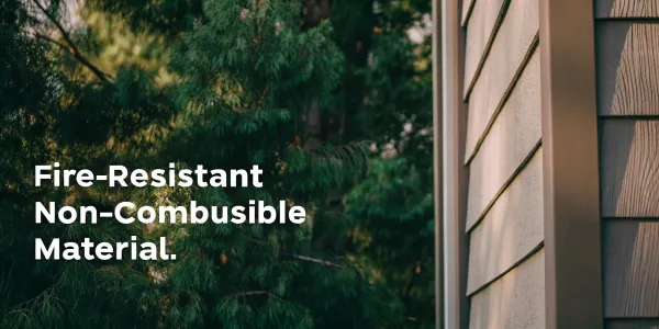
Harden Your Home Against Embers and Flames
Most homes lost to wildfire are ignited by wind-blown embers, not the main fire front. “Home hardening” means using building materials and installation practices that resist ignition from these embers. Start with your roof, which is the most vulnerable part of your house. A Class A fire-rated roof made of composite shingles, metal, or tile is your best defense. Next, focus on vents. Cover all attic, eave, and foundation vents with 1/8-inch metal mesh to block embers from entering. Ensure your windows are double-paned, as the heat from a wildfire can shatter single-pane glass, allowing embers inside. Making your home more resistant to fire is a critical investment in its survival.
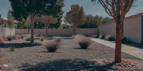
Choose and Maintain Fire-Safe Landscaping
Your landscaping can either be a liability or an asset during a wildfire. The goal is to create a landscape that is less likely to ignite and spread flames to your home. Avoid planting dense, flammable vegetation close to the house. Instead, choose high-moisture, native plants that are naturally more fire-resistant. Create "fuel breaks" like walkways, patios, and gravel paths to interrupt the path of a fire. Proper maintenance is key. Regularly clear away dead vegetation, mow dry grass, and keep trees well-pruned. A thoughtful forest management plan, even on a residential scale, can significantly reduce your property’s fuel load and overall fire hazard.
Prepare a Clear Evacuation Plan
Protecting your property is important, but ensuring your family’s safety is paramount. A well-thought-out evacuation plan is non-negotiable. This plan should include multiple escape routes from your neighborhood, a designated meeting place for your family, and a communication plan in case you get separated. Pack "go bags" for each family member with essentials like water, food, medications, and important documents. Practice your evacuation route so everyone knows what to do when seconds count. You can start building a personalized and comprehensive Wildfire Action Plan today to make sure your family is prepared for any emergency.
How New Wildfire Models Are Changing California Insurance
If you’re feeling confused and frustrated by your home insurance policy, you’re not alone. The ground is shifting beneath our feet as insurers change how they evaluate wildfire risk. The old methods of looking at a property’s location on a static map are no longer enough. Insurers are now using sophisticated, data-driven models to predict future wildfire behavior with much greater detail. Understanding this new approach is the first step toward protecting your home and your policy. These new models look at everything from the type of vegetation on your property to the slope of your land, generating a specific risk score that directly impacts your rates and insurability.
Why Insurers Use New Tech, Not Just FHSZ Maps
Relying only on past wildfire data to predict future events has become unreliable as fires grow in frequency and intensity. Because of this, the California Department of Insurance has introduced a Sustainable Insurance Strategy that allows insurers to use new, "forward-looking" catastrophe models. Instead of just looking at historical fire perimeters, these complex computer models simulate thousands of potential future wildfire scenarios. They analyze factors like weather patterns, wind speeds, vegetation density, and topography to create a much more detailed picture of a specific property’s vulnerability. This shift allows them to price policies with a level of precision that static Fire Hazard Severity Zone (FHSZ) maps could never provide.
The Link Between Risk Scores, Rate Hikes, and Non-Renewals
These new models generate a wildfire risk score for your property, and that score has real-world consequences. Insurers use it to decide whether to offer you a policy, how much your premium will be, and whether they will renew your coverage. A high risk score can lead directly to a steep rate hike or a dreaded non-renewal letter in your mailbox. This is why some neighbors might keep their coverage while others on the same street are dropped. The situation has become so challenging that some major carriers have decided to stop writing new policies altogether in California, leaving many homeowners scrambling for options.
Risk vs. Hazard: What Your Insurer Actually Sees
It’s crucial to understand the difference between "hazard" and "risk," because your insurer certainly does. A hazard is a physical condition that can’t be changed—like living in a region with hot, dry winds or on a steep, chaparral-covered slope. Official Fire Hazard Severity Zone maps show hazard. Risk, on the other hand, is the actual potential for loss or damage to your specific home. The good news is that you have significant control over your property’s risk. By taking proactive steps to harden your home and manage the vegetation around it, you can lower your risk even if you live in a high-hazard area.
How to Improve Your Risk Score and Keep Your Coverage
You are not powerless in this new insurance landscape. You can directly influence your property’s risk score by taking proven mitigation steps. Creating defensible space by clearing flammable vegetation around your home is one of the most effective actions you can take. Hardening your home with fire-resistant materials—like installing fine mesh over vents to block embers and ensuring you have a Class A fire-rated roof—also makes a huge difference. Under California law, insurers are required to provide discounts for these mitigation efforts. The key is to be systematic and thorough. Creating a personalized Wildfire Action Plan can help you identify your property’s unique vulnerabilities and tackle them one by one.
Related Articles
- How to Do a Wildfire Home Assessment in NorCal
- CA High Risk Fire Insurance Map: A 2025 Guide
- How to Find Your Wildfire Vulnerability Score
- Wildfire Risk Insurance: A Complete Guide
Frequently Asked Questions
My home is in a 'Very High' Fire Hazard Severity Zone. Does this mean I'll automatically lose my insurance? Not necessarily. While your zone is a key factor, it's more of a starting point for insurers than a final verdict. They are increasingly focused on your property's specific risk, which you can control. If you take serious steps to create defensible space and harden your home with fire-resistant materials, you can significantly lower your risk profile. Think of the zone as the neighborhood's general hazard, but your actions determine your home's individual vulnerability.
If I have a limited budget, where should I start to make the biggest impact on my wildfire risk? Focus on preventing ignition from embers, as they are the primary cause of home loss in wildfires. Your roof is the most vulnerable surface, so ensuring it's a Class A fire-rated material is the top priority. After that, address any openings where embers can enter your home. Covering all vents with 1/8-inch metal mesh is a low-cost, high-impact project. These two steps—securing your roof and vents—provide the most critical protection for your investment.
How can I prove to my insurance company that I've made my home safer? Documentation is your best tool. Keep detailed records of all the mitigation work you do, including receipts for materials and invoices from contractors. Take before-and-after photos of your defensible space and any home hardening projects, like a new roof or vent screens. When you speak with your agent, provide them with a clear, organized summary of these improvements. A professional wildfire risk assessment can also provide credible, third-party documentation that shows you are proactively managing your risk.
Why did my neighbor keep their insurance policy when mine was non-renewed, even though we live on the same street? This often comes down to the new, highly detailed risk models insurers are using. These models go far beyond the general hazard zone of your street. They analyze property-specific details like the type of roofing material, the exact distance to dense vegetation, and the slope of the land under your home. Your neighbor may have a newer, fire-rated roof or more effective defensible space, giving their property a lower risk score even if you're just a few doors down.
Is creating defensible space just about clearing a bunch of trees and brush? It's much more strategic than that. While managing vegetation is a huge part of it, true defensible space is about creating zones of defense. The most critical area is the first five feet around your home, which should be completely free of anything combustible—no bark mulch, no flammable plants, no firewood. Further out, it's about thinning vegetation, removing dead material, and pruning trees to break the path of a fire. It’s an ongoing maintenance task, not a one-time clear-cut.