Understanding California's High Risk Fire Map
Get clear answers on the high risk fire insurance California map, how it affects your coverage, and practical steps to protect your home in wildfire zones.
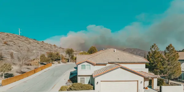
Living in California means living with wildfire risk, but lately, the bigger worry for many is the insurance crisis. A non-renewal notice or a shocking premium increase can feel like a punch to the gut, leaving you confused and powerless. Much of this anxiety is tied to the state's official Fire Hazard Severity Zone maps. Seeing your home on a high risk fire insurance california map can be alarming, but it doesn't have to be a final verdict on your insurability. This guide will demystify these maps, explaining what they actually mean, how insurers use them, and most importantly, what you can do about it. We’ll give you the clear, actionable steps to reduce your risk and take back control.
Key Takeaways
- Know Your Zone, Know Your Starting Point: Use CAL FIRE's official maps to find your property's Fire Hazard Severity Zone. This designation isn't a final judgment on your home's safety but a crucial tool for understanding the baseline environmental risk you face.
- Focus on Action, Not Just the Map: Your most effective strategy is to reduce your property's vulnerability through direct action. Prioritize creating defensible space by managing vegetation and hardening your home against embers with fire-resistant vents, roofing, and windows.
- Document Everything to Prove Your Case: Your mitigation efforts are only valuable to insurers if they know about them. Meticulously document your work with photos and receipts to create a compelling record of your home's reduced risk when speaking with your provider.
What Are California's Fire Hazard Maps?
If you live in California, you’ve likely heard about fire hazard maps. Officially known as Fire Hazard Severity Zone (FHSZ) maps, these are tools developed by CAL FIRE to show the likelihood and potential severity of wildfires across the state. Think of them as a guide to understanding the baseline fire threat in your neighborhood. They are designed to help communities, local governments, and homeowners like you recognize and prepare for the risks you face. These maps are a critical first step in understanding your property’s relationship with wildfire, which directly informs your insurance, building codes, and personal safety planning.
What Do Fire Hazard Zones Mean for You?
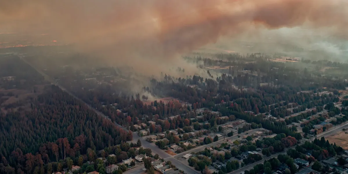
Seeing your home in a yellow, orange, or red zone on a map can be unsettling, but it’s important to understand what it means. These colors represent different levels of risk—from moderate to very high. The latest maps show that wildfire-prone areas have expanded significantly over the last decade, placing more communities in higher-risk zones. For homeowners, your zone designation carries real-world implications. It can trigger stricter building codes for new construction or remodels, requiring fire-resistant materials. It also means you have a greater responsibility to maintain your property and create defensible space to protect your home and help firefighters. Understanding your zone is the starting point for taking meaningful action.
How Are These Zones Determined?
The fire hazard maps are not arbitrary; they are the result of extensive scientific modeling and on-the-ground analysis. CAL FIRE considers a wide range of factors to determine a zone’s rating, including the area's fire history, local topography like canyons and slopes, typical weather patterns such as wind, and the types of vegetation that could fuel a fire. The models even account for how far burning embers can travel, a primary cause of home ignition during a wildfire. It’s crucial to know that these maps are based on the natural landscape and environmental conditions, not on the specific fire-preparedness measures of an individual home. Your property is rated based on its location, not its condition.
How Fire Zones Impact Your Property and Community
While the California Department of Insurance states that official CAL FIRE maps do not directly dictate your insurance rates, they have a significant indirect effect. Insurers use their own sophisticated risk models that often consider the same data. Being in a high-risk zone also brings specific legal requirements. For instance, new homes must be built with fire-resistant materials and construction methods. If you sell your home, you are legally required to disclose the property’s fire risk to potential buyers using a specific form. These regulations are in place to build more resilient communities and ensure everyone is aware of the risks involved in living in a wildfire-prone area.
How to Find and Read Your Fire Risk Map
Knowing your property’s official fire risk designation is one of the first, most powerful steps you can take. This isn't about getting a scary label slapped on your home; it's about gaining the clarity you need to take effective action. State-designated Fire Hazard Severity Zones (FHSZ) are used by state and local agencies to identify areas where wildfire risk is significant. Increasingly, these maps are also influencing how insurance companies assess your property. Understanding where your home falls on the map gives you a starting point for creating a targeted plan to protect your family and your investment. Think of it as your roadmap—it shows you the terrain so you can choose the best path forward.
Where to Find Official Fire Maps and Tools
The most reliable source for this information is CAL FIRE. You don’t have to guess or rely on third-party data that might be outdated. The state provides an official, interactive map that makes finding your zone straightforward.
You can use the online map viewer on the CAL FIRE website to enter your address and see your property's specific designation. This is the definitive source used for state-level planning and regulation. Having this official information is crucial when discussing your property with insurance agents, contractors, or local fire officials. It ensures everyone is working from the same set of facts, which is essential for building an effective wildfire action plan.
How to Understand Map Classifications
When you look up your property, you’ll see it falls into one of three Fire Hazard Severity Zones: Moderate, High, or Very High. These classifications aren't arbitrary. They are based on a scientific assessment of the physical conditions that affect the likelihood and behavior of a fire in that area.
The maps analyze factors like local topography (steep slopes can speed up a fire), climate patterns, and the type and density of surrounding vegetation, which acts as fuel. A "Very High" rating doesn't mean your home is doomed; it simply means the surrounding environment has the ingredients for a more intense wildfire. Understanding this helps you focus your efforts. For example, if you're in a zone with dense vegetation, creating defensible space becomes even more critical.
Local vs. State Responsibility Areas: What's the Difference?
You might also hear the terms State Responsibility Area (SRA) and Local Responsibility Area (LRA). In simple terms, this distinction identifies which agency has the primary financial responsibility for wildfire prevention and suppression. SRAs are typically the wildlands where the state takes the lead, while LRAs are often within city limits where local fire departments are in charge.
The updated FHSZ maps for SRAs became official in April 2024, with maps for LRAs rolling out in 2025. It’s important to know that these maps are designed to predict the chance of a wildfire starting in a given area based on landscape factors, not how a fire might spread from house to house in a dense neighborhood. This is a key distinction—it highlights the risk in the natural environment around you, reinforcing the need for home hardening and community-wide preparedness.
What Determines Your Property's Fire Risk?
Your property’s wildfire risk isn’t based on a single factor. Instead, it’s a complex picture painted by your environment, your home’s characteristics, and the actions you take. State agencies and insurance companies analyze a combination of large-scale environmental conditions and property-specific details to build a complete risk profile. Some of these elements, like the slope of your land, are out of your control. Others, like the vegetation in your yard, are things you can actively manage to make your home safer and more insurable. Understanding what goes into this assessment is the first step toward taking meaningful action.
How Environment and Terrain Affect Your Rating
The natural landscape surrounding your home plays a huge role in its risk assessment. CAL FIRE’s official Fire Hazard Severity Zone maps are built on scientific analysis of the environment. Key factors include terrain, local weather patterns, and vegetation. For example, homes on steep slopes are at greater risk because fire spreads uphill quickly. The type of vegetation also matters—dense chaparral is more flammable than sparse oak woodland. These maps provide a high-level view of the inherent risk in your area before any mitigation efforts are even considered.
The Role of Historical Fire Data
Past events are often the best predictor of future risk. Fire agencies and insurers don’t just look at the current landscape; they study decades of fire history. The official hazard maps consider where fires have occurred before, how frequently, and how intensely they burned. If your neighborhood has a documented history of wildfires, it will likely be rated as having a higher risk. This data-driven approach helps create a more accurate picture of how likely a fire is to start and spread in your specific location, moving risk assessment from a guess to an educated calculation.
Why Local Infrastructure Matters
Your home isn't an island. The resources and preparedness of your broader community contribute to your property’s safety. This includes the capacity of your local fire department, the reliability of water sources for firefighting, and the accessibility of roads for emergency vehicles and evacuations. A community with a well-equipped fire station, clear evacuation routes, and active public education programs is better prepared to manage a wildfire. Insurers may look at these community-level factors when assessing risk, as strong local infrastructure can help stop a small fire from becoming a catastrophe.
The Impact of Vegetation Management
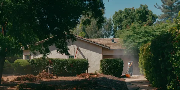
This is where you have the most control. While you can’t change the weather or the terrain, you can significantly reduce your home’s vulnerability by managing the fuel around it. The single most effective thing you can do is create and maintain defensible space—a buffer between your home and the surrounding vegetation. This involves clearing dead plants, trimming trees, and choosing fire-resistant landscaping. By reducing the fuel a fire has to burn, you lower the odds that embers will ignite your home. Documenting this work is a critical part of demonstrating your proactive efforts to insurers and is a core component of a strong Wildfire Action Plan.
How Fire Risk Maps Affect Your Home Insurance
Seeing your home located in a high-risk fire zone on a map can be unsettling, especially when you start thinking about your insurance. The relationship between these maps and your policy isn't always straightforward, but understanding it is the first step toward taking control. Insurers are looking closely at wildfire risk, and that scrutiny is driving the non-renewals and premium hikes that are frustrating so many California homeowners. But a high-risk designation doesn't mean you're out of options. It means it’s time to get proactive about how you manage your property’s risk and present it to insurers.
Finding Insurance in High-Risk Zones
If you live in a high-risk area, your first question is likely, "Can I even get insurance?" The answer is yes, but it may take more work. Officially, the California Department of Insurance states that CAL FIRE's Fire Hazard Severity Zone maps are not supposed to be the sole factor in determining your rates or eligibility. However, the reality is that insurance companies use their own sophisticated risk models that analyze many of the same factors—like slope, vegetation, and weather patterns—that go into the state’s maps.
This is why finding a standard policy can be challenging. Insurers are carefully managing their exposure in areas they deem too risky. But this doesn't mean you're without options. It means you need to focus on what you can control: making your home more fire-resistant and exploring all available coverage avenues, from standard carriers to the state's FAIR Plan.
Why Your Premiums and Coverage Are Changing
The sticker shock from a new insurance bill or the anxiety of a non-renewal notice is a shared experience for many homeowners in fire-prone regions. These changes aren't arbitrary; they reflect a fundamental shift in how insurers view wildfire risk. With recent fire seasons causing billions in insured losses, companies are using advanced catastrophe models to price policies in a way that reflects the real, on-the-ground danger.
Essentially, insurers are trying to ensure they can pay out claims for the next major fire without going bankrupt. They are looking at your property’s specific risk profile with a fine-toothed comb. While the updated state maps might not be the direct cause of a premium hike, they are part of a larger trend of using better data to assess wildfire risk. Your premium is a direct reflection of the risk an insurer believes they are taking on by covering your home.
What Is the California FAIR Plan?
When you can't find coverage in the standard market, the California FAIR Plan acts as a safety net. It’s not a state agency but an association of all licensed property insurers in California, created to be an insurer of last resort. The FAIR Plan provides basic fire insurance for high-risk properties that private companies won't cover.
However, it’s important to understand its limitations. A FAIR Plan policy is not a replacement for a comprehensive homeowners policy. It typically only covers damage from fire and smoke. You will likely need to purchase a separate "Difference in Conditions" policy from a private insurer to cover other risks like theft, water damage, and liability. While it’s a crucial option, it’s often more expensive and provides less coverage, making it a temporary solution while you work to make your home insurable on the private market again.
How Insurers Assess Your Property's Risk
An insurer’s assessment goes far beyond just looking at a map. They are evaluating the unique characteristics of your property to determine its specific vulnerability. Think of it as a detailed risk audit. They analyze factors like your home’s construction materials, the age and type of your roof, and whether your vents are ember-resistant.
They also look at your immediate surroundings. Do you have a well-maintained defensible space clear of flammable vegetation? Is your property on a steep, brush-covered slope? They consider your access to roads for emergency services and the local fire department's response time. Each of these elements contributes to your home’s overall risk score, which directly influences your eligibility and premiums. The more you do to reduce these risks, the better your chances of securing affordable coverage.
Debunking Common Insurance Myths
Navigating the insurance landscape is confusing enough without misinformation. Let’s clear up a few common myths. The biggest one is that being in a high-risk zone automatically means you can't get insurance. This is simply not true. While it is more difficult, options like the FAIR Plan and surplus line carriers exist. More importantly, taking proven mitigation steps can make your home attractive to private insurers again.
Another myth is that there’s nothing you can do to change your situation. This couldn't be further from the truth. You have significant power to lower your risk. Creating defensible space and hardening your home against embers are concrete actions that insurers recognize and value. Documenting this work is key. By taking charge of your property’s resilience, you can directly influence your insurability. The first step is to build a clear, expert-backed wildfire action plan to guide your efforts.
Lower Your Fire Risk (and Insurance Premiums)
Taking steps to protect your home from wildfire does more than give you peace of mind—it can also make your property more attractive to insurers. In California, new regulations are pushing insurance companies to recognize and reward homeowners for their mitigation efforts. By proactively reducing your property’s risk, you can improve your chances of keeping your coverage and potentially lower your premiums. It’s about taking control in a situation that can often feel overwhelming. The key is to focus on two main areas: creating a buffer around your home and strengthening the structure itself.
Create Your Defensible Space
Defensible space is the buffer you create between your home and the surrounding grass, trees, and shrubs. This area is essential for slowing or stopping the spread of a wildfire and gives firefighters a safer space to defend your home. Think of it as removing the fuel that a fire needs to reach your house. The most effective thing you can do is to reduce or eliminate nearby fuel sources.
Start with these critical actions:
- Clear your immediate surroundings: Within the first five feet of your home, remove all flammable materials. This includes dead leaves, pine needles, woodpiles, and bark mulch. Use non-combustible options like gravel or rock instead.
- Manage vegetation: In the zone extending 30 feet from your home, keep grass mowed to a maximum of four inches. Create space between trees and remove lower branches to prevent a ground fire from climbing into the canopy.
- Maintain your property: Regularly clean your roof and gutters of leaves and other debris, as these are prime spots for embers to land and ignite.
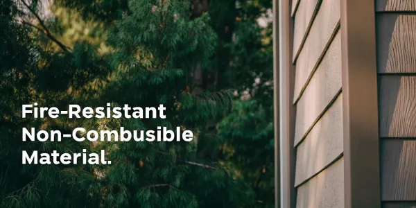
Harden Your Home Against Embers
Most homes lost in wildfires are not ignited by direct flames but by wind-blown embers. These small, burning pieces of debris can travel a mile or more ahead of a fire, lodging in small crevices and starting new fires. "Hardening" your home means using building materials and installation techniques that resist ignition from embers.
Key home hardening measures include:
- Secure your vents: Cover all attic, eave, and foundation vents with 1/8-inch metal mesh to prevent embers from entering.
- Upgrade windows and doors: Install dual-paned windows, preferably with tempered glass on the exterior pane. Ensure weather stripping on your doors, including the garage, is in good condition to seal any gaps.
- Use fire-resistant materials: When it’s time to replace your roof or siding, choose Class A fire-rated materials like asphalt shingles, metal, or tile.
Document Your Mitigation Work for Insurers
Your insurance company can’t see the hard work you’ve put into making your home safer unless you show them. Meticulous documentation is your proof. When you complete a mitigation project, whether it’s clearing brush or installing a new roof, you need to create a record.
Start by creating a comprehensive file for your property. Include:
- Before-and-after photos of your defensible space and home hardening projects.
- Receipts and invoices for materials purchased and professional services hired.
- A detailed list of all mitigation actions taken, with dates of completion.
Insurers use their own complex models to assess risk, but providing them with property-specific data gives them a more accurate picture. A tool like the Wildfire Action Plan can help you organize this information, creating a clear and professional report to share with your insurance provider.
Find Opportunities to Lower Your Premiums
With your documentation in hand, it’s time to be proactive. California’s “Safer from Wildfires” framework created a list of mitigation actions that insurers are now required to consider when setting your premiums. This means your hard work can translate directly into savings.
Contact your insurance agent or carrier and formally request a review of your policy based on your mitigation efforts. Send them your complete documentation package and ask specifically what discounts are available. While not every company offers significant savings yet, providing clear evidence of your risk reduction is the best way to make your case. Even if a discount isn't immediately available, these actions are the most important investment you can make in the safety of your home and family.
Finding the Right Insurance Solution
Finding affordable, reliable home insurance in a high-risk fire area can feel overwhelming, especially after a non-renewal notice. But it’s not an impossible task. The key is to be proactive, informed, and persistent. Think of this as a strategic process where you gather information, present your home as a lower risk, and explore every available path to coverage. By understanding how insurers operate and what options you have, you can take back a sense of control and find a solution that protects your family and your property.
Explore Your Coverage Options
Your first step is to understand the landscape. While official state maps are important, the California Department of Insurance clarifies that CAL FIRE's Fire Hazard Severity Zone maps do not directly determine your insurance rates or eligibility. Instead, insurers use their own models. This means you need to shop around. Don’t assume one company’s “no” is the final answer. Work with an independent insurance agent who specializes in high-risk properties. They have access to multiple carriers, including standard “admitted” insurers, and can help you compare quotes. They can also explain other options if the standard market isn't available to you.
How to Work with Your Insurance Provider
Open communication with your insurance provider is critical. Since insurance companies use their own computerized models to assess risk, you need to ask them directly what matters most. Call your agent and ask for specifics: “What home hardening measures could lower my premium?” or “What type of defensible space documentation do you require?” Keep a detailed record of every mitigation project you complete, with photos, receipts, and dates. A comprehensive record, like the one you can build with a Wildfire Action Plan, demonstrates your commitment to reducing risk and makes you a more attractive client to insurers.
Understand Your Policy's Requirements
Once you secure a policy, read it carefully. Your coverage often depends on you meeting specific requirements. For example, your policy might mandate that you maintain a certain type of roofing material or keep your defensible space clear of flammable vegetation. It’s also important to know that official maps often predict the chance of a wildfire starting, not how it might spread from house to house in a dense neighborhood—a phenomenon called a “conflagration.” Your insurer’s assessment will likely account for this, so understanding their view of your property’s unique risk is essential for maintaining your coverage.
Look into Alternative Insurance Solutions
If you’ve exhausted options in the standard market, don’t panic. There are alternatives. You may be able to find coverage through a surplus line carrier, which is an insurer that is not regulated by the state and often covers higher-risk properties at a higher cost. The last resort for many homeowners is the California FAIR Plan. It provides basic fire coverage when you can’t get it elsewhere, though it’s typically more expensive and less comprehensive than a standard policy. While some homeowners worry that new hazard labels will make insurance harder to get, viewing these alternatives as a bridge—not a dead end—is key. They can provide protection while you continue your mitigation efforts to become eligible for the standard market again.
What's Next for Fire Risk and Insurance?
The landscape of wildfire risk and home insurance is constantly shifting. As technology improves and climate patterns change, the way risk is measured, priced, and managed is also evolving. For homeowners in high-risk areas, staying ahead of these changes is key to maintaining affordable coverage and keeping your family safe. Here’s a look at the trends shaping the future and what you can do about them.
The Rise of Advanced Mapping Technology
Wildfire risk mapping is becoming more precise. Recently, Cal Fire released updated Fire Hazard Severity Zone maps for the first time in over a decade, showing a significant expansion of high-danger areas across the state. Using advanced data on weather, vegetation, and topography, these tools provide a much clearer picture of where the greatest threats lie. For homeowners, this means you can get a more accurate understanding of your property’s specific vulnerabilities. While seeing your home in a higher-risk zone can be unsettling, this detailed information also empowers you to focus your mitigation efforts where they will have the most impact.
What to Expect from the Insurance Market
A common fear is that new, more detailed risk maps will automatically lead to non-renewals or soaring premiums. However, the reality is that insurance companies have been using their own sophisticated risk models for years. While the state’s official maps provide a public benchmark, many insurers already use similar, or even more granular, data to underwrite policies. The market is unlikely to change overnight because of these maps alone. Instead, the trend of insurers looking closely at property-level mitigation—like defensible space and home hardening—will only intensify. Your proactive efforts are your best tool for staying insurable.
Keep an Eye on Regulatory Changes
The rules governing California’s insurance market are in flux. While the California Department of Insurance has stated that official Fire Hazard Severity Zone maps do not directly dictate insurance rates, the department is making other significant changes. New regulations are allowing insurers to incorporate forward-looking catastrophe models into their rate-setting process, which could change how premiums are calculated. Staying aware of these regulatory shifts is important, but your primary focus should remain on what you can control: reducing your property’s vulnerability to wildfire. This is the most reliable way to positively influence an insurer’s decision.
How Climate Change Shapes Future Risk
The expansion of high-hazard zones on the new maps is not random; it’s a direct reflection of a changing climate. Warmer temperatures, prolonged droughts, and more extreme fire weather are making landscapes more flammable. This trend is expected to continue, meaning that areas once considered low-risk may face new threats in the coming years. This reality underscores the importance of long-term preparedness. Creating a resilient home and community isn't a one-time fix but an ongoing commitment. Understanding your specific risk is the first step, and a personalized Wildfire Action Plan can give you a clear, actionable strategy to protect what matters most.
Related Articles
- How to Get CA Home Insurance in High Fire Risk Areas
- Protect Your Home: Top 10 Wildfire Prevention Measures
- A Step-by-Step Home Wildfire Risk Assessment
Frequently Asked Questions
Do these new fire hazard maps mean I'm going to lose my insurance? Not automatically. While the maps are an important public tool, insurance companies have been using their own sophisticated risk models for years. Their decision to offer or renew a policy is based on their own detailed assessment of your property's specific risk. Think of the new maps as a clear signal to get proactive about reducing your risk, not as a final verdict on your insurability.
My home is in a high-risk zone. What are the first steps I should take? Start with what you can control right outside your door. The most impactful first step is creating defensible space, beginning with the five-foot zone immediately surrounding your home. Clear out all flammable materials like dead leaves, bark mulch, and woodpiles from this area. This single action dramatically reduces the chance that wind-blown embers—the primary cause of home ignition—will find fuel next to your house.
How can I prove to my insurer that I've made my home safer? Documentation is everything. You need to create a clear and detailed record of all your mitigation work. Take before-and-after photos of your defensible space projects and any home hardening upgrades, like installing new vents or a Class A roof. Keep all receipts and invoices for materials and labor. A well-organized file proves to your insurer that you are serious about reducing risk, which can make a real difference in their assessment.
Why might my insurer drop me if the state says these maps don't dictate rates? It's true that state maps don't directly set insurance rates. However, insurance companies use their own private, and often more detailed, risk models that analyze many of the same factors, including vegetation, slope, and weather history. Their decision is based on their own calculation of your property's specific risk. If their model determines the risk is too high for a standard policy, they may issue a non-renewal.
Is the California FAIR Plan my only option if I can't find coverage? The FAIR Plan is a crucial safety net, but it may not be your only alternative. An independent insurance agent who specializes in high-risk areas might be able to find coverage with a surplus line carrier. It's best to view the FAIR Plan as an insurer of last resort that provides essential fire protection while you continue to improve your home's resilience and work toward qualifying for a standard policy again.